
 Tweet
Tweet
I got idea for this recently when saw Carl's comments on other topic.
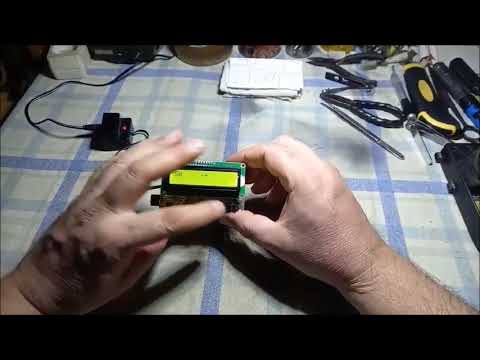
It is stand alone device, having own 18650 Lipo battery, automatic USB charger for that battery, LCD, 2 button, BT module.
Based on Atmega328P.
I am working more on it to make it compatible with my Win&Android logging and 3D displaying software.
It uses signal derived from headphones socket from any PI detector (or even some other types) which can produce variable audio frequency audio.
So it can be used also with some VLF I/B's, most certainly with all type of BFO's and many other devices with similar audio output.
It has it's own speaker to replace the speaker in the detector, since when headphones are plugged in detector; usually internal speaker is switched off.
To overcome that; i added speaker to the device to keep the audio from detector audible and working properly.
There are two buttons, one to take a sample (immediate send it via BT to Win&Android software) and another to switch between rows/columns.
I named it "180 Turn" but as at my magnetometer; it can switch to another column in both cases; "parallel" or "zig-zag" walking the soil matrix.
This is set and defined in Win&Android software and simple button press only tells the software to step to another column.
Why this kind of device?
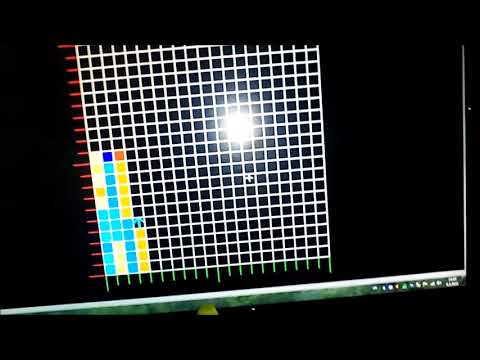
There are people who will want to "map" the soil with PI detector and ... say... 1x1m coil.
On the real soil such signal can be of high resolution, varying in just small steps. And if target is large (larger than coil size) but also very deep and producing weak mum response; usually such targets are not understood and noticed good by operators.
In most of the cases such weak and mum responses will be taken as false signals from the ground.
But later if mapped on larger area on soil; such weak signals can literally "draw" a pretty easy recognizable contours of a large target.
That's most important reason why this device... and other less important can be in fact that many hobbyists will simply like to map certain areas on soil and have those records backed up in archive, for future analyzes.
It is stand alone device, having own 18650 Lipo battery, automatic USB charger for that battery, LCD, 2 button, BT module.
Based on Atmega328P.
I am working more on it to make it compatible with my Win&Android logging and 3D displaying software.
It uses signal derived from headphones socket from any PI detector (or even some other types) which can produce variable audio frequency audio.
So it can be used also with some VLF I/B's, most certainly with all type of BFO's and many other devices with similar audio output.
It has it's own speaker to replace the speaker in the detector, since when headphones are plugged in detector; usually internal speaker is switched off.
To overcome that; i added speaker to the device to keep the audio from detector audible and working properly.
There are two buttons, one to take a sample (immediate send it via BT to Win&Android software) and another to switch between rows/columns.
I named it "180 Turn" but as at my magnetometer; it can switch to another column in both cases; "parallel" or "zig-zag" walking the soil matrix.
This is set and defined in Win&Android software and simple button press only tells the software to step to another column.
Why this kind of device?
There are people who will want to "map" the soil with PI detector and ... say... 1x1m coil.
On the real soil such signal can be of high resolution, varying in just small steps. And if target is large (larger than coil size) but also very deep and producing weak mum response; usually such targets are not understood and noticed good by operators.
In most of the cases such weak and mum responses will be taken as false signals from the ground.
But later if mapped on larger area on soil; such weak signals can literally "draw" a pretty easy recognizable contours of a large target.
That's most important reason why this device... and other less important can be in fact that many hobbyists will simply like to map certain areas on soil and have those records backed up in archive, for future analyzes.


Comment